Conodoguinet Creek Watershed Association

A non-profit, environmentally concerned citizens group created to take appropriate action on matters that affect the welfare of the Conodoguinet Creek Watershed.

We are having a membership drive! We want YOU to join us!
Become a CCWA Member today!

Join us under the Membership Tab

Winter 2026 Freshet

To Protect & Clean; to Advocate & Educate

Inside this Edition CCWA Gets New VP; Chase McGraw Muskellunge; CCWA Memories from 2025; Winter Postcard: Good Hope Mill; PA Waterway Stats; and Conodoguinet Classifieds!

If you get a list of files rather than the PDF opening, you may need to right-click on a PDF file, select “Open with” > “Choose another app”, select “Adobe Acrobat Reader” or “Adobe Acrobat”; then either check the “Always use this app to open .pdf files” box (if using Windows), or click “Change All” (on a Mac). If that does not work you may need to adjust your browser settings to download or open PDFs in your system’s default program.   

A Long Way with Many Bends

Conodoguinet Creek Watershed Association

Commemorative Booklet

This booklet is one part of a larger commemorative project that CELEBRATES the Conodoguinet Creek Watershed Association’s people, projects, and changes the organization has witnessed. It provides some of the history and stories of the watershed. Along with this booklet, oral history videos captured in partnership with the Cumberland County Historical Society and Dickinson College, and a story map created by Shippensburg University provide a sense for the passionate professionals and volunteers who have made the CCWA a resilient community presence over the past 30 years and, hopefully, who will continue to do so for many years to come.
Click on the photo to the left to learn more about our Watershed and the inspiration behind CCWA.
A Long Way With Many Bends is a visual story of Pennsylvania’s Conodoguinet Creek and Watershed, the Conodoguinet Creek Water Trail, and the Conodoguinet Creek Watershed Association.

Conodoguinet Creek flows 104.5 miles (168.1km) from high on the Kittatinny Ridge, down through the fertile Cumberland Valley, and into the Susquehanna River near Harrisburg. The name of the creek is borrowed from Native American words and means “A Long Way with Many Bends.” This stunning natural resource is a regional attraction that offers residents and visitors meaningful economic, recreational, and environmental value.

The lower 40 miles of the creek comprise the Conodoguinet Creek Water Trail, which is a recreational trail meandering through agricultural lands, and small towns. This section is an important part of the Pennsylvania Water Trails Partnerships program.

The Conodoguinet Creek Watershed Association (CCWA) is a non-profit, environmentally concerned citizens group created to take appropriate action on matters that affect the welfare of the Conodoguinet Creek Watershed.

You can explore the Conodoguinet Creek and Watershed by watching videos, reading text, following links, and interacting with the geology and water trail maps. The story map is designed to feature topics regarding the Conodoguinet Creek Watershed such as the importance of watershed education, conservation, geology, agriculture, riparian buffers, and recreation. The spirit of multi-generational volunteerism among community and partner organizations is a theme throughout the story map. 

This story map illustrates how community and volunteerism connect education and conservation principles to enhance the health of the Conodoguinet Creek Watershed. The health of our local watershed affects the water quality of the Conodoguinet Creek that flows downstream into the Susquehanna River, to the Chesapeake Bay, and ultimately our global oceans.  

CCWA hopes that the story map experience inspires you to explore the Conodoguinet Creek though recreation, connect with people, and act by volunteering with CCWA and with our many partners as stewards of our shared environment. Conodoguinet Creek Watershed Association appreciates the grant funding from the Pennsylvania Environmental Council and creation of the story map by Shippensburg University – Center for Land Use & Sustainability.

A Long Way With Many Bends, is a digital story map that showcases a virtual tour of the Conodoguinet Creek and Watershed

Share the Conodoguinet Creek Digital Story Map Virtual Tour with Family and Friends

Dive deeper into the Watershed in the “Creek and Its Watershed” videos.
Plan your next creek outing on the the “Explore the Water Trail” interactive map.
Learn how you can improve our watershed under the “Riparian Buffers” videos.
View the Watershed in a unique perspective using the interactive Geology map.
Understand the role of Agriculture in our watershed under the “Agriculture” videos.
Get involved by learning more with the “About the CCWA” and “Partners” videos.

HIGHLIGHTS - CHECK OUT
HOW YOU CAN VOLUNTEER

CCWA CREEK CLEANUPS

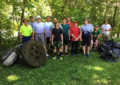
Every 3rd Saturday (8:45 am - Noon) May - September.
Cleanups are very dependent upon weather conditions and stream height.
Creek Clean-up registration is TBA

CCWA TREE PLANTING

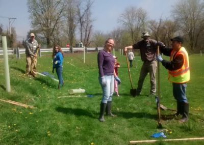
Volunteer to help us plant trees! Partners are Camp Hill Borough and Chesapeake Bay Foundation the Keystone 10 Million Tree Partnership.
Tree planting registration is TBA

STREAM TEAM WATER MONITORING

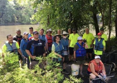
Watershed Monitoring in Partnership with ALLARM to conduct MONTHLY water testing. Members will meet on site and use field kits for water quality monitoring data.
Email allarm@dickinson.edu or (717) 243-5121

CCWA Membership Form

Please complete your contact information and select your Membership Type.

Address